Knight is a satellite observatory dedicated to Egypt's northern coastal lakes — the great Nile-Delta lagoons (Manzala, Burullus, Idku, Bardawil) that lie between the delta and the Mediterranean. These lakes are among Egypt's most productive fisheries and most important wetland ecosystems, and among its most stressed: decades of drainage, land reclamation, pollution loading, aquaculture and aquatic-vegetation encroachment have reshaped them. Yet routine, objective, whole-lake measurement of how they are changing has been scarce.
Knight fills that gap from space. Its first operational lake is Lake Manzala — historically Egypt's largest northern lake — monitored continuously and openly using public satellite missions, on the same engine that powers the Hapi African Water Observatory. It is a focused, delta-scale complement to Hapi's basin-scale reservoirs and rivers.
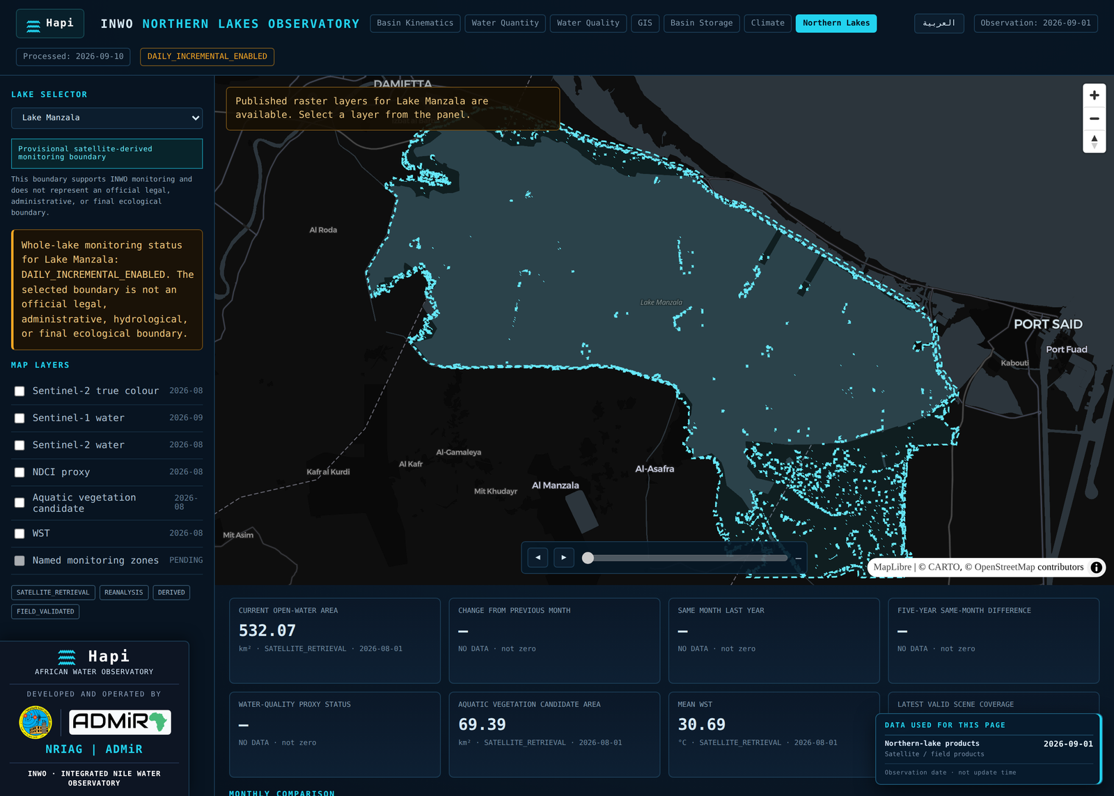
At a glance: Lake Manzala live (first lake) · record span 1984–2026 · 20 variables tracked · ∼532 km² open water · ∼69 km² aquatic vegetation.
What Knight monitors (Lake Manzala)
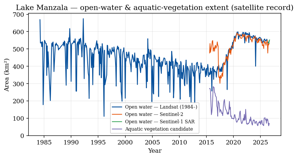
- Open-water extent — the lagoon's open-water area from three independent sensors — Landsat back to 1984, Sentinel-2, and all-weather Sentinel-1 radar — capturing long-term contraction, seasonal change and reclamation.
- Aquatic vegetation — candidate aquatic-vegetation area, tracking the encroachment of reeds and floating plants that fragment open water and choke fisheries channels.
- Water quality — Sentinel-2 chlorophyll/bloom (NDCI), floating-algae (FAI), and turbidity proxies — a spatial screening layer for eutrophication and pollution plumes where field sampling is sparse.
- Thermal & hydroclimate — lake water-surface temperature, plus the ERA5-Land climate context (air temperature, precipitation, evaporation, wind) that drives the lagoon.
Why it matters
- Fisheries & livelihoods — the northern lakes underpin a large share of Egypt's inland catch; open-water loss and vegetation encroachment directly threaten it.
- Ecosystem & biodiversity — internationally important wetlands and migratory-bird habitat under sustained pressure.
- Water quality & public health — the lakes receive agricultural and municipal drainage; satellite screening flags eutrophication and turbidity plumes for follow-up.
- Coastal adaptation — low-lying delta lagoons are on the front line of sea-level rise and subsidence; a continuous baseline is essential for adaptation planning (SDG 6, SDG 13, SDG 14).
Knight monitors the whole lake from satellite and reports only real observations. The current lake boundary is a provisional, satellite-derived monitoring outline — not an official legal, administrative, hydrological, or ecological boundary. Named internal zones and in-situ field validation are not yet integrated, and the quality indices are provisional proxies, not laboratory concentrations. Nothing is fabricated or inferred from literature.
How it works
Knight runs on the Hapi/INWO engine and open satellite data: Landsat (1984–), Sentinel-2, Sentinel-1 SAR, and ERA5-Land. Each lake is described once in a registry (geometry, zones, thresholds), and the engine detects open water and vegetation, retrieves quality and thermal indices, and serves them through a dedicated Northern Lakes dashboard. Adding the next lake (Burullus, Idku, Bardawil) is a configuration step, not new software. The same data-integrity discipline as Hapi applies throughout: no synthetic data, explicit gaps, provenance, and reproducibility.
Roadmap
- Now: Lake Manzala live — whole-lake open water, vegetation, quality, thermal, and climate (1984–2026).
- Next: extend to Burullus, Idku, and Bardawil; add named monitoring zones once boundaries are authorized.
- Then: integrate in-situ field campaigns to calibrate the water-quality proxies, and connect drainage-outlet monitoring.
Developed & operated by
Knight is developed and operated by the National Research Institute of Astronomy and Geophysics (NRIAG), Egypt, and ADMiR, on the Hapi — African Water Observatory platform, using open data from ESA/Copernicus and NASA/USGS.
Access
Delivered on the Hapi — African Water Observatory platform. Contact: elgabry@nriag.sci.eg (NRIAG)